User Tag List

Thanks useful information Thanks useful information:  4
Results 1 to 12 of 12

Thread: Results of 8 days of rain

  1. #1
    Member
    Join Date
    16 Sep 2011
    Location
    Canberra
    Posts
    1,217
    Mentioned
    0 Post(s)
    Tagged
    0 Thread(s)

    Results of 8 days of rain

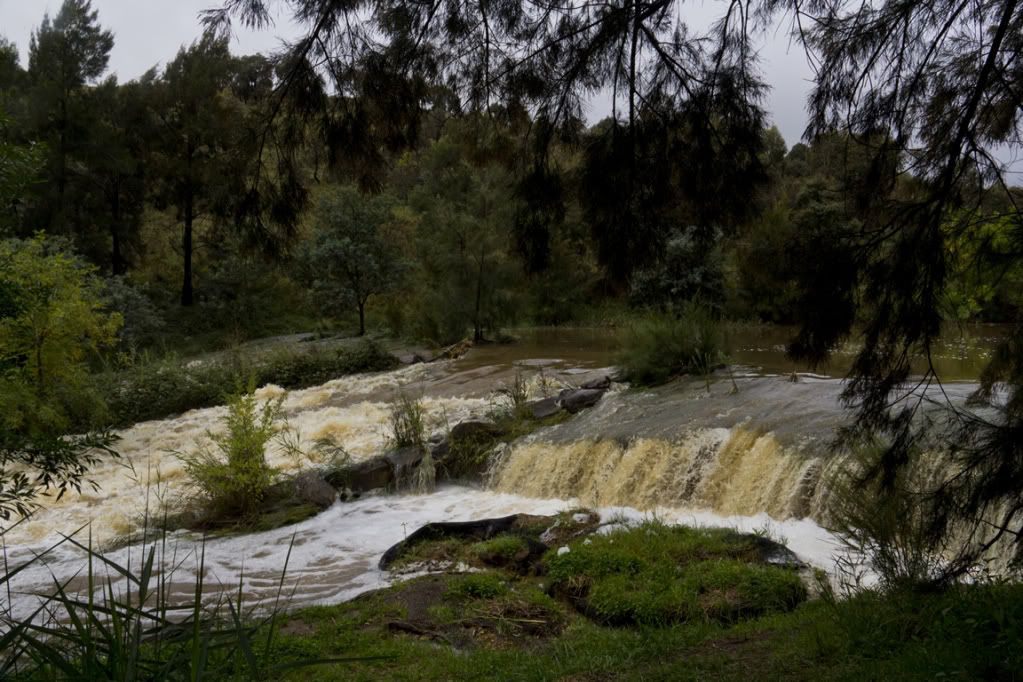
    This small creek used to run slowly through the central portion.


    I wouldn't drive my 4wd across this section of a local bike path. That water was moving pretty darned fast.


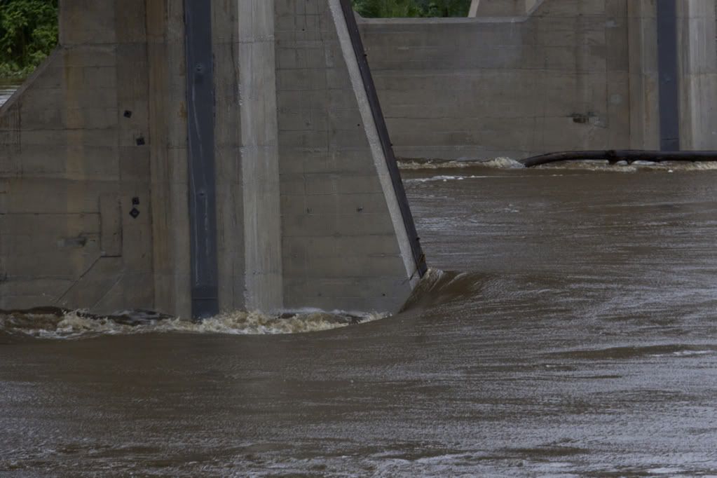
    There are some ledges that we used to climb up OUT OF THE WATER to get to, to sit and have a rest while swimming, somewhere under all that water going under the Tharwa Bridge.


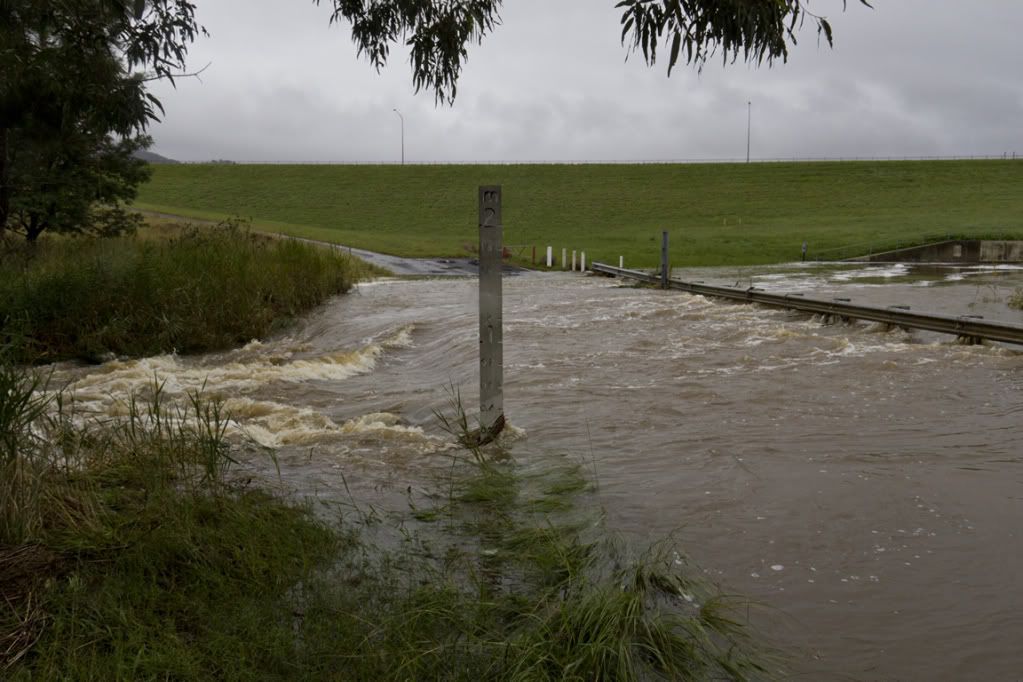
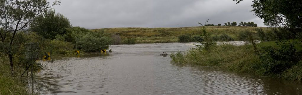
    The Point Hut Crossing road used to go from right to left, just in front of those background trees.


    The Point Hut Crossing Road vanishing into the depths.


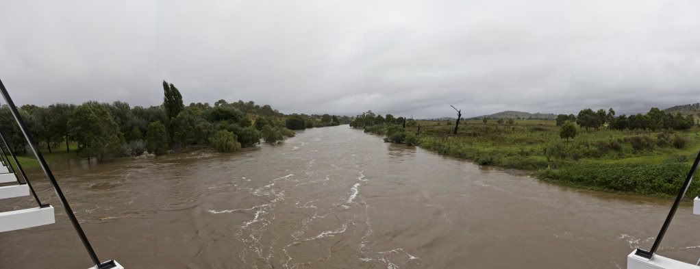
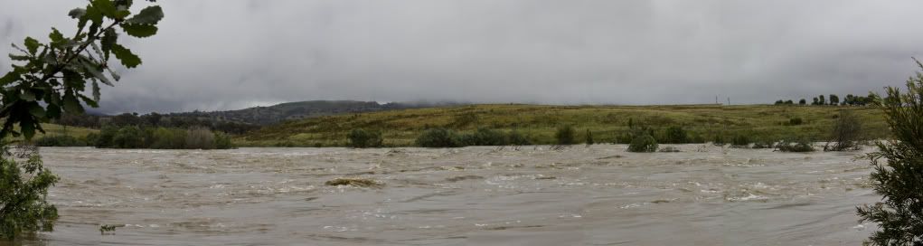
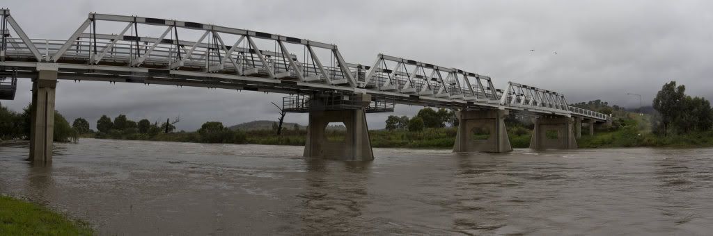
    A quite poorly stitched attempt at a pano to show how much wider the river now is at the Tharwa Bridge. It normally flows mostly between the two central supports, with small amounts going around the sides.


    Another somewhat dodgy stitching attempt to show the width of the river under the Tharwa Bridge at the moment. The submerged trees to the left are the usual picnicing area, where many a fine Christmas Lunch has been had by the family.
    Canon EOS 60D ..... EFS 18-200mm f/3.5 - 5.6 IS - 430 EXII Speedlite - "eBay special" Remote Control Unit - Manfrotto 190XPROB w 804RC2 head.

  2. #2
    Administrator ricktas's Avatar
    Join Date
    24 Jun 2007
    Location
    Hobart
    Posts
    16,846
    Mentioned
    12 Post(s)
    Tagged
    1 Thread(s)
    Thanks for sharing these. Many more to come from all over NSW and Vic at present, I feel. Stay safe!
    "It is one thing to make a picture of what a person looks like, it is another thing to make a portrait of who they are" - Paul Caponigro

    Constructive Critique of my photographs is always appreciated
    Nikon, etc!

    RICK
    My Photography

  3. #3
    Ausphotography Regular
    Join Date
    20 Feb 2012
    Location
    Brisbane
    Posts
    867
    Mentioned
    0 Post(s)
    Tagged
    0 Thread(s)
    Impressive. Can you post "before" or "after" shots so we can compare these tot he "normal" situation?
    I hope you didn't do anything risky or illegal to get these shot from the bridge!

  4. #4
    Member
    Threadstarter

    Join Date
    16 Sep 2011
    Location
    Canberra
    Posts
    1,217
    Mentioned
    0 Post(s)
    Tagged
    0 Thread(s)
    Funny you should say that. The bridge were the "legal" ones.
    The others the Rangers had the road closed and said no-one could go down there. I asked if I could walk down to take some photos and got told no, and that I could get photos from the bridge several kms away. So I did. But on the way back as I drove past where the Rangers had the road blocked, I saw a number of other people walking down the old road some half a km away, that is now a bike path. This path is the other side of a small ridge from the Rangers, so feeling like a rebel for the first time in my life (always been a mega "goody-two-shoes" who doesn't do these sorts of things) I decided to also walk down the bike path as well.

    That was when I found why the road was closed, and why the bike path wasn't. A car had rolled on the road the night before, and they were probably stopping people going down the road, not because of the flooded road, but because of the accident scene. They didn't seem to care about the bike path.
    However, I didn't so much as get a foot wet taking the photos. Every shot was taken from carefully chosen places where the ground was firm, no risk of collapse into the water, and where the water at that spot was still water so if I had somehow miraculously ended up in the water, I'd not get washed away. I was keen for a shot, but I'm not going to die for a photo. I was probably too careful as there were some better vantage points I'd have liked to try but wasn't prepared to risk them. I have way too much respect for emergency personnel who'd end up having to rescue me to put myself in any risk at all.
    I don't have current photos of the area that I know of, but can always resurrect this thread when the water levels return to normal levels and post some new (better stitched) photos (I knew I should have taken the tripod. Makes panning for panos so much more succesful to stitch.

  5. #5
    Member Opus40's Avatar
    Join Date
    03 Apr 2011
    Location
    Petrie
    Posts
    54
    Mentioned
    0 Post(s)
    Tagged
    0 Thread(s)
    It is amazing how much water is around atm. our back yard had a small creek about 2 meters wide and yester day it was about 50m across. thanks for sharing

  6. #6
    Member
    Join Date
    15 May 2011
    Location
    Sydney
    Posts
    671
    Mentioned
    0 Post(s)
    Tagged
    0 Thread(s)
    in January this was the river flowing under Tharwa bridge


    Cartel Imagery
    Flickr


    Nikon D7000
    Sony a65
    Canon 5D MKII

  7. #7
    Member
    Threadstarter

    Join Date
    16 Sep 2011
    Location
    Canberra
    Posts
    1,217
    Mentioned
    0 Post(s)
    Tagged
    0 Thread(s)
    Wow. Thanks Mechawombat for those pics. I knew it was a heap wider, but those shots really give the width of water above some real perspective.

    There's only one "hole" in each pylon now visible, where there used to be two. The ledges we used to climb up on to have a rest are much deeper down than I thought. I'd mistaken them for being just under the water in my pics, but forgot there were two holes, and looking at your pics, those ledges are a probably 10 to 12 feet under. Wow!
    Last edited by Ezookiel; 08-03-2012 at 9:22pm.

  8. #8
    Member
    Join Date
    15 May 2011
    Location
    Sydney
    Posts
    671
    Mentioned
    0 Post(s)
    Tagged
    0 Thread(s)
    Yeah when I saw your shots I was AMAZED considering we walked around right around the pylons next to the river

  9. #9
    Member
    Join Date
    25 Mar 2011
    Location
    Launceston
    Posts
    48
    Mentioned
    0 Post(s)
    Tagged
    0 Thread(s)
    Thanks for the images

  10. #10
    Member
    Join Date
    15 Jun 2011
    Location
    Sydney
    Posts
    759
    Mentioned
    0 Post(s)
    Tagged
    0 Thread(s)
    Oh my god, so much water !! I didn't realise the scale of the first photos until the "after" shots. Wow.

    Decided to "shave" my signature ;]
    Now mostly shoots with: Canon 5D MK3 & Canon 24-70 f/2.8/50mm f/1.8 (also have a 550D with a variety of lenses/goodies and a Sony Nex-5N)
    PP with: Lightroom only, Photoshop is merely a 9-5 work tool for me.

  11. #11
    Member DoubleMint's Avatar
    Join Date
    22 Mar 2012
    Location
    Canberra
    Posts
    10
    Mentioned
    0 Post(s)
    Tagged
    0 Thread(s)
    how do people cross that bridge???

  12. #12
    Member
    Threadstarter

    Join Date
    16 Sep 2011
    Location
    Canberra
    Posts
    1,217
    Mentioned
    0 Post(s)
    Tagged
    0 Thread(s)
    Quote Originally Posted by DoubleMint View Post
    how do people cross that bridge???
    If using a car, they have to cross In single file only.
    Have to stop and wait till anyone already on the bridge has exited.
    There are a couple of alcoves on the bridge for pedestrians to hop into if a car comes while you're walking across (my last shot was taken from in one of them)
    But in honesty, there's probably room for a pedestrian and a careful driver without using the alcoves.
    "Completed in March 1895, the Tharwa Bridge located at Tharwa, Australian Capital Territory, was the second Allan truss to be built, the
    oldest surviving bridge in the Australian Capital Territory and the oldest, longest in continuous use Allan truss bridge
    .."
    Of course, that also means that half the time the damned thing is closed for repairs. Allan Truss are a maintenance heavy type apparently, and there are reasons there are so few remaining ones around.

    There is a good aerial shot of the bridge someone else has taken at this link, and it also shows really well how little water normally flows under the bridge, though a lot of the grey area has been built up by the roadworks and stuff that they are doing under, around, and on the bridge to try to prevent the constant maintenance needs > http://www.google.com.au/imgres?imgu...9QEwBQ&dur=520

    And here is one taken by someone that calls themself Bidgee, at Wikimedia (clever play on Wikipedia), which actually shows how you get across the bridge > http://commons.wikimedia.org/wiki/Fi...e_at_Thawa.jpg
    Last edited by Ezookiel; 23-03-2012 at 12:00pm.

Posting Permissions

  • You may not post new threads
  • You may not post replies
  • You may not post attachments
  • You may not edit your posts
  •